Photogrammetry Mapping UAV SOP: From Pre-Flight to Processing
A comprehensive guide to standard operating procedures for photogrammetry mapping projects, covering accuracy, fidelity, and actionable data delivery.
Read More →Is LiDAR or Photogrammetry Better for Mapping and Inspections in 2025? A comprehensive comparison of LiDAR workflow vs. drone photogrammetry to help you choose the right technology for your project.

While savvy utilities, solar and wind operators, real estate landlords, and infrastructure owners understand the value-add of drone-based photogrammetry, fewer are privy to the differentiation that LiDAR provides.
Rather than taking photos and stitching them together to produce high-quality maps (photogrammetry), LiDAR leans on lasers to map the world around it. And in doing so, it creates much denser point clouds - millions of precise measurements that capture not just the surfaces of roofs or roads, but the true geometry of terrain, vegetation, and structures.
This density translates into engineering-grade accuracy (not survey grade without a surveyor's stamp), the ability to penetrate foliage to reveal bare earth, and reliable 3D models even in low-light/no-light or uniform-surface conditions where cameras often struggle.
Where photogrammetry excels at texture and visual context, LiDAR delivers hard data: precise elevations, volumetric measurements, and structural dimensions that underpin flood modeling, asset management, and construction verification. For owners of critical infrastructure, it's a leap from pretty pictures to actionable, survey-grade intelligence.
As LiDAR gets cheaper and more miniaturized, won't it eat photogrammetry's lunch? It's not that simple. Let's ignore cost comparisons for now and focus solely on the edge that each type of capture holds in reality capture.
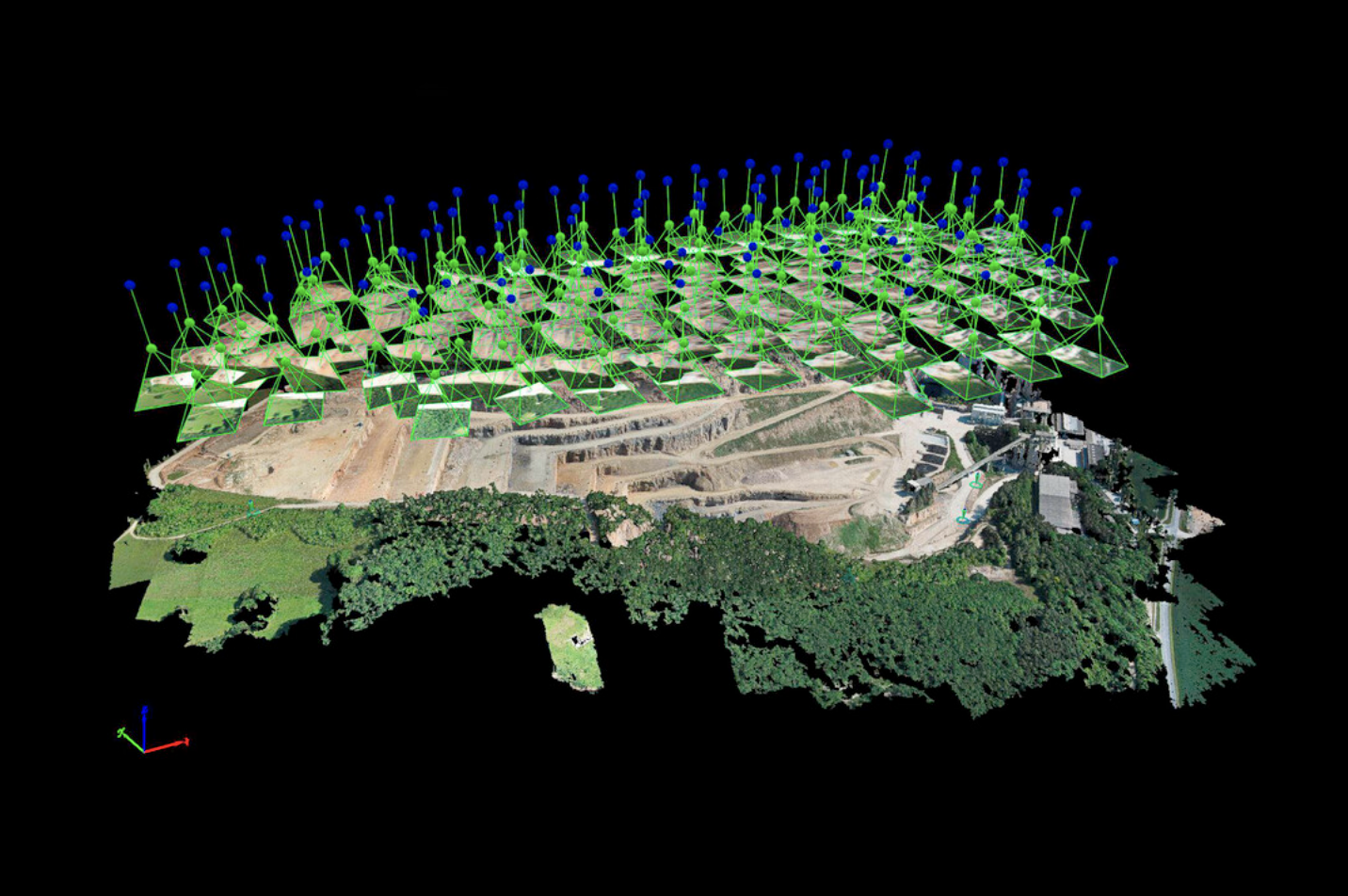
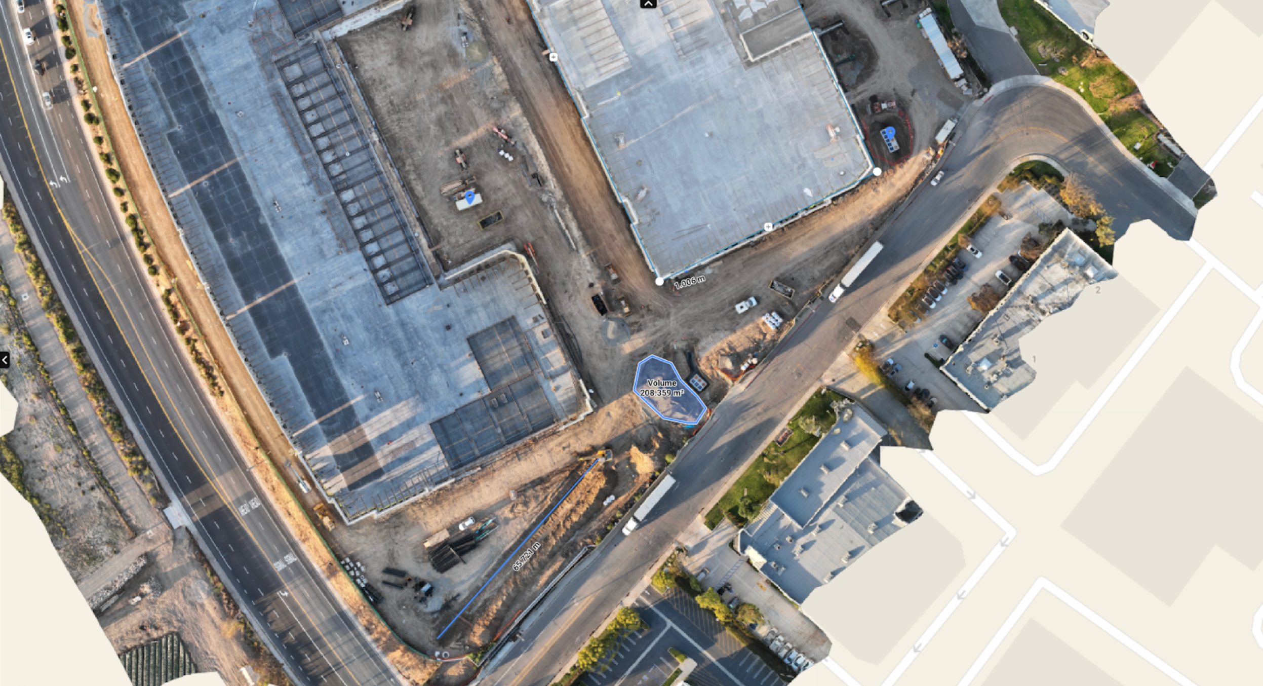
A photogrammetry "point cloud" is created via stitching of geo-referenced photos
LiDAR excels at geometry, but its raw point clouds are intensity-only - essentially grayscale. Photogrammetry delivers high-resolution RGB textures that bring assets to life. For inspection reports, visual storytelling, and stakeholder presentations, that context matters just as much as measurements. LiDAR workflows often include a separate RGB sensor for dual-capture to address this point - a LiDAR/RGB dual capture - photogrammetry and LiDAR working together.
While LiDAR offers survey-grade accuracy, photogrammetry can achieve sub-centimeter surface detail. This level of resolution makes it ideal for detecting small defects such as cracks, corrosion, or shingle damage. For many projects, fine surface detail outweighs raw 3D accuracy.
LiDAR point clouds are large, complex, and require specialized software. By contrast, photogrammetry outputs orthomosaics and 3D models that are lighter, easier to share, and more compatible with existing workflows. For many clients, a clean georeferenced map or visual 3D deliverable is all they need — without managing terabytes of LiDAR data.
Not every project requires LiDAR's accuracy. For many use cases, a lightweight RGB camera drone offers a faster, cheaper, and more practical option. When the goal is visualization rather than engineering tolerances, photogrammetry wins on ease of deployment and affordability.
Fill out a pilot profile on RAAD.com now and start receiving mission opportunities.
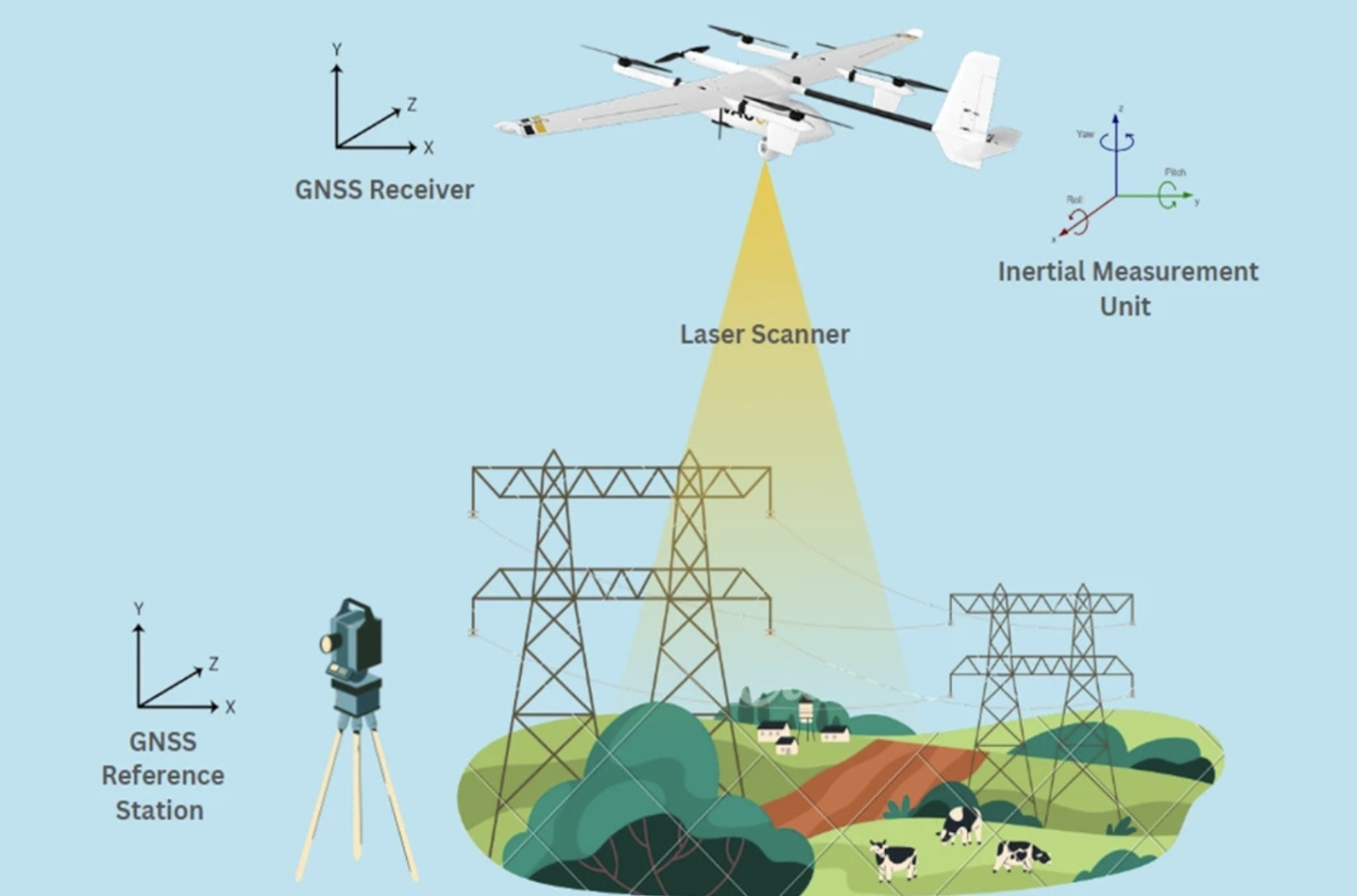
A LiDAR point cloud is made by measuring laser pulse returns to map millions of 3D points
LiDAR's laser pulses can pass through trees and brush, hitting the ground surface beneath. This makes it possible to generate accurate bare-earth models even in dense canopy — something photogrammetry can't achieve. For asset owners in utilities, forestry, and floodplain management, that ground-level visibility is critical.
Unlike photogrammetry, which estimates depth by comparing overlapping photos, LiDAR directly measures distance with lasers. The result: vertical accuracy within 2–5 cm or better. That precision is good enough for CAD design, BIM integration, and infrastructure inspections, ensuring operators can make engineering decisions without sending out costly ground crews.
As an active sensor, LiDAR doesn't rely on sunlight or surface texture. LiDAR emits lasers that hit the surface and bounce back. This technology doesn't depend on light reflecting back off of the surfaces - eliminating poor capture results in areas with shadows. It can capture reliable data in low light, at night, and over uniform surfaces like snow, sand, or flat roofs. That makes it ideal for time-sensitive models when conditions aren't perfect.
Photogrammetry's accuracy depends on visible surface detail and lighting, but LiDAR generates evenly spaced 3D points across every surface. This uniformity is essential for engineering-grade digital twins, automated analysis, and precise asset measurements.
While the hardware investment is higher, LiDAR surveys often reduce re-flights, cut manual correction, and shorten fieldwork time. That efficiency translates into faster inspection cycles, lower operational costs, and less disruption to ongoing operations.
Photogrammetry will continue to dominate visual inspections, while LiDAR, especially as it gets cheaper and more portable, will become the standard for precision applications.
LiDAR is not limited to pre-planning. It is the tool of choice anytime perfect measurement is required: surveying, siting, disaster risk assessment such as landslides and floods, earthworks change detection, and creating hyper-accurate as-built 3D models. Its strength lies in capturing the exact geometry of terrain and structures, where accuracy rather than visuals drives decisions.
Today, most commercial drone work still leans on RGB cameras. They are inexpensive, easy to deploy, and produce visually rich deliverables that customers understand. Photogrammetry also benefits from familiarity: nearly every pilot can fly the hardware, and processing software is abundant. That is why it continues to be applied even in engineering-heavy contexts.
As LiDAR becomes normalized, affordable, and miniaturized, it will dominate workflows where errors are unacceptable. In pre-construction, precision underpins everything. Earthworks, material volumes, drainage, utilities, and site layout all hinge on an accurate base model. A small error at this stage cascades into massive downstream costs, so willingness to pay for accuracy is high.
Meanwhile, photogrammetry remains indispensable for monitoring and maintenance, where visual context matters more than absolute precision. Detecting solar hotspots, checking façades for leaks, spotting sagging power lines, or documenting long-term asset change are all areas where RGB is better suited.
In short: LiDAR owns precision, photogrammetry owns context.
LiDAR builds the world; photogrammetry watches it age.
Fill out a pilot profile on RAAD.com now and start receiving mission opportunities.

Chief Executive Officer
Repeat entrepreneur on a mission to modernize how we understand the infrastructure we all rely on.
A comprehensive guide to standard operating procedures for photogrammetry mapping projects, covering accuracy, fidelity, and actionable data delivery.
Read More →