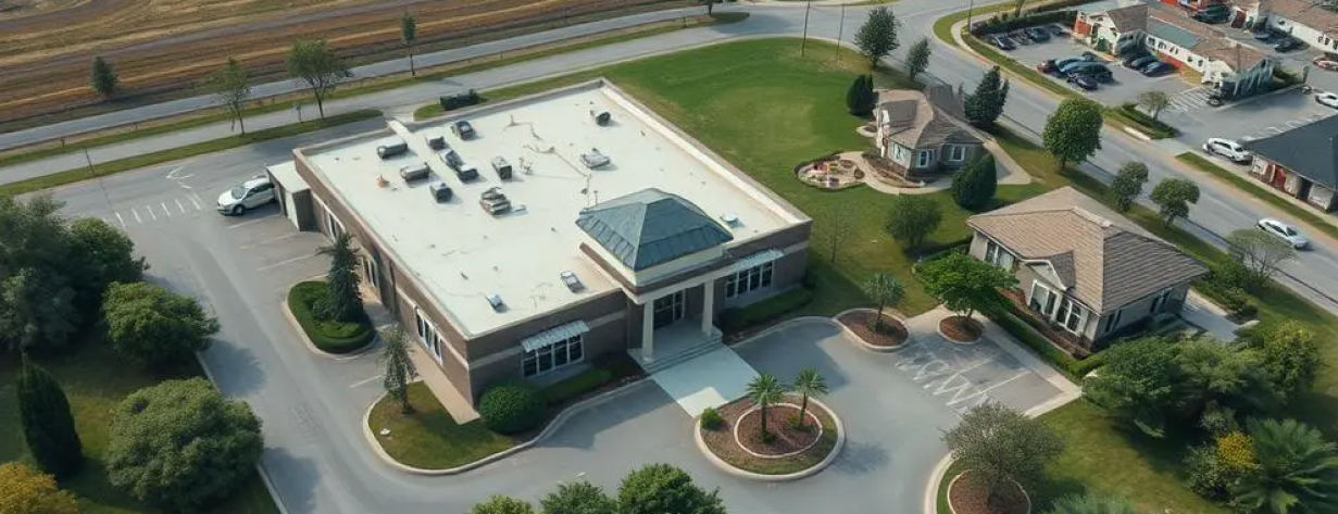
RAAD Logo
Aerial view of commercial property highlighting key features

CLOSE DEALS FASTER WITH CAPTIVATING AERIAL PROPERTY TOURS

Stop relying on ground-level views. Attract more qualified buyers and tenants with stunning aerial photography, cinematic video, and detailed site context provided by Raad's nationwide network of specialized property drone pilots.

01

MARKETING
PHOTOGRAPHY & VIDEO

Stunning aerial imagery and cinematic video that showcases your property's features, context, and unique selling points for maximum market impact.

02

PROPERTY
INSPECTION

Comprehensive visual and thermal assessments of roofs, facades, and infrastructure to identify issues and document condition without scaffolding or lifts.

03

SITE MAPPING &
VISUALIZATION

Detailed orthomosaic maps, 3D models, and virtual tours that provide accurate measurements and immersive property experiences for buyers and stakeholders.

CUT THROUGH MARKET NOISE & SHOWCASE TRUE PROPERTY VALUE

CHALLENGES

Standard photos struggle to capture the full scope, condition, and advantageous context of diverse properties, from sprawling industrial sites and land tracts to multi-family complexes and unique residential estates. Effectively conveying site access, surrounding amenities, structural integrity, and overall appeal is difficult, leading to unqualified inquiries, longer listing times, and missed opportunities.

SOLUTIONS

Make your listings impossible to ignore. Raad delivers high-impact aerial visuals and data that command attention. Our certified pilots create compelling photos, immersive videos, detailed site overviews, and inspection data that highlight key selling points. Attract genuinely interested prospects, provide comprehensive remote viewing experiences, and accelerate your entire transaction cycle.

COMPREHENSIVE AERIAL TOOLS FOR MARKETING & PROPERTY ASSESSMENT

HIGH-RESOLUTION AERIAL PHOTOGRAPHY

Striking, detailed images from multiple angles and altitudes showcasing the entire property, its scale, features, and surroundings.

CINEMATIC PROPERTY VIDEOS

Engaging, professional video tours highlighting property flow, key features, infrastructure access, and lifestyle/location advantages.

IMMERSIVE 360° PANORAMAS & VIRTUAL TOURS

Allow potential clients to explore the property and its environment remotely in detail.

SITE CONTEXT & AMENITY MAPPING

Orthomosaic maps and annotated visuals clearly displaying lot lines, access routes, proximity to highways, transit, schools, shopping, and other key amenities.

ROOF & FACADE INSPECTIONS

Detailed visual assessment of building envelope condition for pre-sale due diligence, maintenance planning, or insurance underwriting.

LAND DEVELOPMENT VISUALIZATION

Showcase the potential of vacant land, highlighting topography, zoning boundaries, and suitability for development.

CONSTRUCTION PROGRESS FOR PRE-LEASING/SALES

Document building progress with compelling visuals for marketing efforts before project completion.

LEASE FASTER, SELL HIGHER, MARKET SMARTER ACROSS ALL PROPERTY TYPES

THE VALUE OF AERIAL PROPERTY INTELLIGENCE

DIFFERENTIATE YOUR LISTINGS

Stand out dramatically from competitors using standard photography with professional, eye-catching aerial perspectives.

ATTRACT & QUALIFY LEADS FASTER

Give prospects a comprehensive understanding upfront, reducing wasted showings and attracting serious inquiries.

HIGHLIGHT KEY SELLING POINTS

Clearly demonstrate critical features – logistics advantages, stunning views, property condition, expansion potential, neighborhood context.

ACCELERATE DECISION-MAKING

Provide the visual information buyers/tenants need to feel confident and move forward quickly.

ENHANCE ALL MARKETING MATERIALS

Generate high-quality assets perfect for websites, brochures, MLS listings, social media, and client presentations.

STREAMLINE DUE DILIGENCE

Provide valuable visual data for property condition assessments and inspection reports.

What Leading Brokers, Developers & Property Managers Say

"Raad became one of our most powerful marketing tools for bringing new deals to market and showcasing properties' best features. The platform helped us document multiple sites without hiring or dealing with local drone services providers."

Sam McConkie

Managing Director - Bonneville Real Estate Capital

Certified Professional Drone Pilots

Every pilot in our network undergoes rigorous verification of certifications, insurance coverage, equipment maintenance, and operational procedures. Our ongoing quality assurance ensures consistent deliverables regardless of project location.

Pilot Qualifications

FAA Part 107
Certification

Commercial drone operation certification required for all professional pilots

Specialized
Waivers

Night operations, flying over people, and other special authorizations

Industry
Training

Specialized training for specific industries and operations

PROPERTY DRONE SERVICE FAQs

Standard deliverables include high-resolution JPEG photos and professionally edited MP4 video files, optimized for web, social media, and print. We can provide raw files upon request and accommodate direct uploads to listing platforms or cloud storage.

Absolutely. During the project brief, you specify key features to emphasize. Pilots capture shots designed to showcase these advantages, and we offer post-production services like adding boundary overlays or annotation callouts.

Standard turnaround for edited photos and basic video is typically 24-72 hours post-flight, depending on project complexity. More complex video editing may take longer. Expedited options are available.

Yes, many pilots in our network are equipped with specialized drones and possess the skills for safe indoor flight operations in large spaces like warehouses, showrooms, or manufacturing facilities, provided conditions allow.

MAKE YOUR PROPERTIES UNFORGETTABLE.
GET NOTICED & TRANSACT FASTER.

Stop blending in. Partner with Raad for stunning aerial visuals that capture attention, communicate value, and drive results for your property listings and assessments.