Minimize downtime, enhance safety, and optimize asset management across your entire utility network. Leverage Raad's nationwide pool of certified pilots for precise inspections and rapid data collection for electric, gas, water, and renewable assets.
Detailed visual and thermal inspection of conductors, insulators, poles, and towers to identify defects and right-of-way conditions.
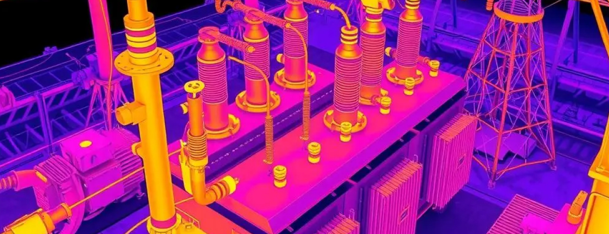
Comprehensive thermal and visual assessment of transformers, breakers, and switches without requiring outages.
Rapid deployment after severe weather events to quickly assess infrastructure damage and enable faster restoration.
Utility providers face constant pressure: maintaining sprawling and often remote infrastructure, ensuring grid reliability, managing vegetation encroachment, responding rapidly to storm damage, and protecting personnel during hazardous manual inspections. Aging assets, regulatory compliance, and the need for cost-effective operations demand smarter, more efficient asset management strategies. Relying solely on ground crews or traditional methods is often slow, expensive, and inherently risky.
Revolutionize your operations with on-demand aerial intelligence. Raad connects you instantly with specialized drone pilots equipped for the unique demands of the utilities sector. Gain unprecedented access for safe, detailed visual and thermal inspections of transmission/distribution lines, substations, pipelines, wind turbines, and solar farms. Accelerate damage assessment, optimize maintenance schedules, and ensure regulatory compliance—all with faster, safer, and more cost-effective drone data.
Detailed visual, thermal (hotspot detection), and LiDAR inspection of conductors, insulators, poles, and towers to identify defects and right-of-way conditions.
Comprehensive thermal and visual assessment of transformers, breakers, switches, and other critical components without requiring outages.
Accurate mapping and analysis of vegetation encroachment along power lines and pipeline corridors for targeted, proactive maintenance.
Aerial surveillance for leak detection (using specialized sensors where applicable), encroachment monitoring, and integrity assessments along pipeline routes.
Efficient blade and tower inspections for wind turbines; thermal and visual inspections of solar panels and arrays to identify defects and optimize performance.
Rapid aerial post-event to quickly identify damaged infrastructure, prioritize repairs, and expedite restoration efforts.
Create accurate digital twins and verify construction of new utility assets.
THE VALUE OF UTILITY DRONES
Significantly reduce exposure to high-voltage environments, working at heights, and navigating hazardous terrain during inspections.
Lower expenses associated with manual inspections (bucket trucks, helicopters, line crews) and minimize costly unplanned outages through predictive maintenance.
Identify potential failure points proactively and accelerate post-storm recovery to minimize customer interruptions.
Target maintenance resources effectively based on precise condition data and vegetation analysis.
Generate detailed, auditable visual records for maintenance logs, environmental compliance, and safety reporting.
Cover vast service territories and inspect numerous assets far faster than traditional ground-based methods.
Every pilot in our network undergoes rigorous verification of certifications, insurance coverage, equipment maintenance, and operational procedures. Our ongoing quality assurance ensures consistent deliverables regardless of project location.
Commercial drone operation certification required for all professional pilots
Night operations, flying over people, and other special authorizations
Specialized training for specific industries and operations
Yes, experienced pilots follow strict safety protocols, utilize appropriate equipment (e.g., non-conductive drones where necessary), and maintain safe standoff distances determined by voltage levels and operational procedures to ensure safe and effective data capture.
Drones equipped with high-resolution zoom cameras can capture detailed imagery identifying small defects like cracked insulators, frayed conductors, or leading-edge erosion on wind turbine blades, often exceeding the detail visible from ground level or helicopters.
We provide data in standard formats compatible with most utility software, including geo-referenced imagery (JPEG), thermal radiometric data (R-JPEG), video (MP4), and processed outputs like orthomosaics (GeoTIFF) or point clouds (LAS). We can tailor deliverables to your specific system requirements.
Our nationwide network enables rapid mobilization. Depending on conditions and FAA airspace restrictions (e.g., Temporary Flight Restrictions), we aim to deploy pilots to affected areas often within hours or the first operational window post-event to provide critical situational awareness.
Enhance safety, boost reliability, and optimize your maintenance budget. Contact Raad to discuss your specific utility inspection needs and access expert drone pilots across your service territory.